|
Read: Exodus 45 (www.biblestudytools.com/nrs/exodus/45.html)
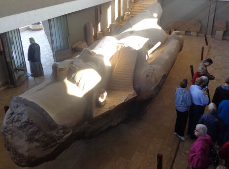
Sing: Go Now in Peace, UMH 665 The Greek name “Memphis” derives from the pyramid of Pepy I in Saqqara which is “Men-nefer” (Established and Beautiful). The city was originally known as Ineb-Hedj or “The White Wall.” Some sources indicate that other versions of the name may have even translated to our modern name for the country, Egypt. During the Middle Kingdom it was Ankh-Tawy or “That Which Binds the Two Lands.” The location of Memphis lies approximately between Upper and Lower Egypt. The importance of this location is demonstrated by the persistent tendency of Memphis to be the Capital of Egypt as Cairo, just to the north, is today. Memphis had no rivals as the capital of the United Kingdom of Upper and Lower Egypt for over a thousand years (3000 -1938 BC). Originating as a fortress whose strength was the dikes which kept it safe from the Nile, Memphis quickly became the administrative and religious center of Egypt. The city must have been huge, judging from the size of its necropolises which extended for some 19 miles along the west plateau of the Nile. Memphis continued to be an important part of Egypt’s culture through the takeover by Alexander the Great and his building of Alexandria as the new capital. Memphis took another shot when Christianity came to Egypt and reduced Memphis’ religious influence. But the death blow did not come until the 7th century AD when the Muslims took over Egypt and built their capital just north of Memphis at Cairo. Remarkably little survives of Memphis largely because the ruins were quarried in the Middle Ages for stone to build Cairo’s churches and mosques. Today, other than the scattered ruins, most of the city is gone, or lies beneath cultivated fields, Nile silt, and local villages. The fraction we can see of Memphis today is located principally around the small village of Mit Rahina. The remains of Ptah’s Temple bordering the village were at one time probably one of the grandest temples in Egypt. Today, only a fraction of the temple remains. Ramses II is well represented here, with a colossus of himself near the Alabaster Sphinx along the southern enclosure wall. It is hard to imagine what Memphis was for almost four thousand years. Our oldest cities in America are not much over five hundred years old! There is so little left of Memphis today but what they have is magnificent. The colossus of Ramses II is awesome even lying down. The Alabaster Sphinx was having some work done on it while we were there but we could still appreciate its beauty. One thing I missed seeing in Memphis was an Elvis impersonator.
0 Comments
Read: Exodus 44 (www.biblestudytools.com/nrs/exodus/44.html)
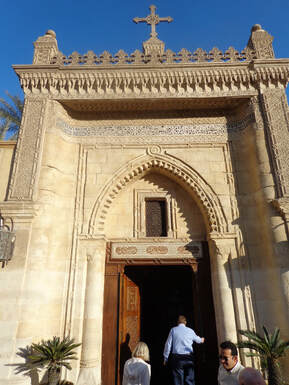
Sing: Draw Us in the Spirit’s Tether, UMH 632 Old Cairo is so named because it predates what is now Cairo. Some historians believe that there was a settlement here as far back as the 6th century BC. The Romans built a fortress here. It became a Christian stronghold, with as many as twenty churches built within an area of one square mile. There are only five of these churches remaining today. Also in the area are the oldest Mosque in Egypt and the oldest synagogue in Egypt. The Cavern Church – Abu Sarga Abu Sarga, the Church of Saint Sergius and Saint Bacchus, also called the Cavern Church, is the oldest church in Egypt and dates back to the 5th century AD. The church owes its fame to having been constructed upon the cavern where the Holy Family stayed for three weeks during their sojourn in Egypt. According to Coptic tradition Joseph, Mary, and Jesus stayed here on their way back to Israel. This church is dedicated to the two saints, Sergius and Bacchus, who served as soldiers in the Roman Army. They were faithful followers of the Lord Jesus and refused to worship the Roman gods. For their Christian belief, Sergius and Bacchus eventually suffered martyrdom in Syria in 296 during the reign of the Roman Emperor Maximinus. The Hanging Church – The Church of the Virgin Mary It is called the Hanging Church because it was built on the southern gate of the Roman Fortress. Logs of palm trees and layers of stones were constructed with the ruins of the fortress as the foundation. From the 7th to the 13th centuries the Hanging Church served as the residence of the Coptic Patriarch. The wood work and the icons of this church are most impressive. The ceiling inside the church is built as a representation of the inside of Noah’s Ark. This was also done in the Cavern Church. These two churches are proof positive that the Christians of Egypt put a high value on the artistic expression of their faith. And in my opinion we are all blessed to have these churches and these people as part of the Body of Christ. Read: Exodus 43 (www.biblestudytools.com/nrs/exodus/43.html)
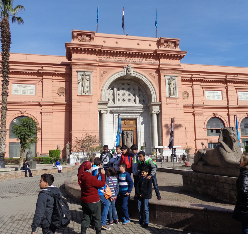
Sing: Jesus, We Want to Meet, UMH 661 The Egyptian Museum of Antiquities is situated at Tahrir Square in Cairo. It was built during the reign of Khedive Abbass Helmi II beginning in 1897, and opened on November 15, 1902. It has 107 halls. At the ground floor there are the huge statues. The upper floor houses small statues, jewels, Tutankhamon treasures and the mummies. The Museum also comprises a photography section and a large library. The Egyptian museum comprises many sections arranged in chronological order: the first section houses Tutankhamon's treasures. The second section houses the pre-dynasty and the Old Kingdom monuments. The third section houses the first intermediate period and the Middle Kingdom monuments. The forth section houses the monuments of the Modern Kingdom. The fifth section houses the monuments of the late period and the Greek and Roman periods. The sixth section houses coins and papyrus. The seventh section houses sarcophagi and scarabs. More than a million and half tourists visit the museum annually, in addition to half a million Egyptians. This was a fantastic museum with so many incredible items – a lot of them were over 4,000 years old! In one stairwell we saw some papyrus documents that were 3,000 years old displayed in simple frames you might buy at Walmart. Our last stop here was the Tutankhamon room – the artistry and skill of the people who created these items easily matches or surpasses what we can do today. The Egyptians have built a new museum in Giza, not far from the Great Pyramids. The Grand Egyptian Museum has more than 258,000 square feet of permanent exhibit space on a 123-acre campus and will open in 2021. Read: Genesis 42 (www.biblestudytools.com/nrs/genesis/42.html)
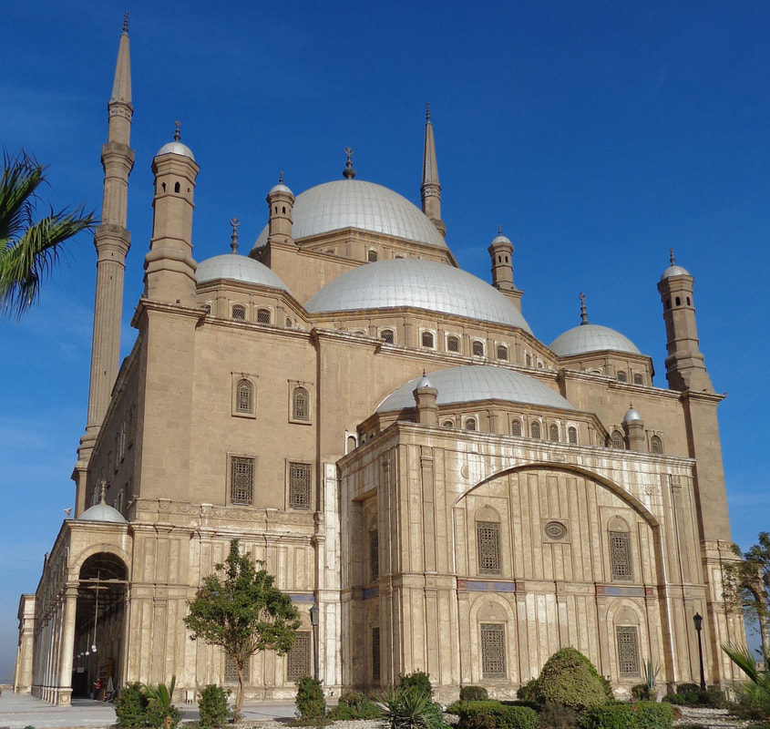
Sing: Come, Sinners, to the Gospel Feast, UMH 616 The Citadel is one of the world’s greatest monuments to medieval warfare. It is a highly visible landmark on Cairo’s east side and is built on a spur of limestone that had been detached from its parent Mogattam Hills by quarrying. This area began its life not as a great military base of operations, but as the “Dome of the Wind,” a pavilion created in 810 AD by Hatim Ibn Hartama, who was then governor. The governors who followed also enjoyed the site’s cool breeze and view of Cairo for the next three hundred years. Between 1176 and 1183 Salah ad-Din Yusuf Ibn al Ayyubi (Saladin) fortified the area to protect it against attacks by the Crusaders, and since then it has never been without a military garrison. Originally it served as both a fortress and a royal city. Salah ad-Din had come from Syria (a Tikrit born Kurd) where each town had some sort of fortress to act as a stronghold for the local ruler. So it was only natural that he would carry this custom to Egypt. Most of the fortifications you see today were built after Salah ad-Din’s rule, being added to by almost every invader since, some of whom destroyed much of what existed before them. The Mohammed Ali Mosque (Alabaster Mosque) Mohammed Ali Pasha al Mas’ud ibn Agha was the ruler of Egypt and founder of the country’s last dynasty of Khedives and Kings. He had this mosque designed by the Greek architect Yussuf Bushnaq and built in the Citadel of Cairo beginning in 1830. The mosque is his tomb and is known as the Alabaster Mosque because of the extensive use of this material. Two architectural features stand out: first, the fifty-four full or partial gray domes of the mosque including the 170 feet high and 69 feet wide main dome. The second feature that stands out is the two minarets. Each slender minaret is 270 feet tall and yet they are each built on a foundation less the ten feet wide. On the west wall of the courtyard is an iron clock, a gift of the French king, with a tea salon on the upper level. It has never worked, and probably never will. Before we entered the mosque we removed our shoes or bought shoe covers – we are asked to do this in order to protect the expensive carpets that cover the floor. The inside is awesome – for its sheer size and its cavernous beauty. Particularly striking was the interplay of the morning sunbeams coming through the eastern windows and the lights suspended from the ceilings. We also enjoyed the parapet of the fortress to which we exited from the mosque. From the top of the Citadel wall we had great views of Cairo to the west. Read: Exodus 41 (www.biblestudytools.com/nrs/Exodus/41.html)
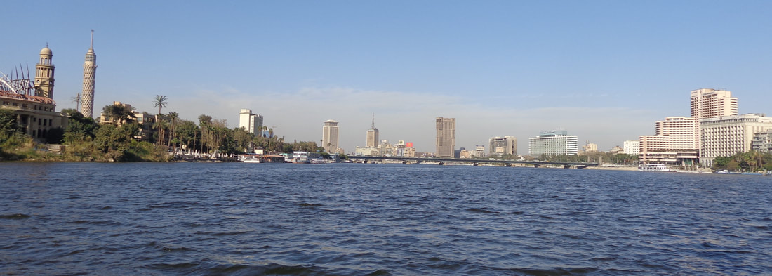
Sing: Deck Thyself, My Soul, with Gladness, UMH 612 The Nile is the longest river in the world. It rises south of the Equator and flows northward through northeastern Africa to drain into the Mediterranean Sea. It has a length of about 4,132 miles and drains an area estimated at 1,293,000 square miles. Its basin includes parts of Tanzania, Burundi, Rwanda, the Democratic Republic of the Congo, Kenya, Uganda, South Sudan, Ethiopia, Sudan, and the cultivated part of Egypt. Its most distant source is the Kagera River in Burundi. In Egypt the Nile is the source of all life – without its water the entire country would look like the desert plateau that is never more than a few miles from the river. Southern Egypt is called Upper Egypt because it is upstream while northern Egypt, including the Delta is called Lower Egypt because it is downstream. In addition to the Valley and the Delta the Nile also divides Egypt into the Western and Eastern Deserts. Today the Nile flows through the Delta in only two principal branches, the Damietta and the Rosetta. This has been another long day of traveling but I am so excited to be in Cairo! Read: Exodus 40 (www.biblestudytools.com/nrs/exodus/40.html)
Sing: Child of Blessing, Child of Promise, UMH 611 Once we crossed the mid-point of the Ahmed Hamdi Tunnel we were officially in Africa! This is now the third continent I have been in – the first was North America, where I was born and have always lived, the second was Asia, which I visited for the first time just a week and a half ago when we landed in Tel Aviv. I will be going to my fourth continent in just a few days when we change planes in Frankfurt, Germany on our way home. Cairo Cairo is the capital of Egypt and the largest city in Africa and one of the largest cities in the world. Cairo had its start in the 4th century AD as a Roman fortress on the Nile River. In 641 the Muslims moved their capital here from Alexandria. The area started to be called by the name Cairo in 969. By the time we got to Cairo it was dark. But we could still see quite a bit because it is a well-lit city. The photo below was taken in the morning from the Citadel. You can see the smog that was hanging over the city every day that we were here. But that was only a part of the filth of the city. As we drove along the highways we could see that two or three feet of the inside lane was filled with dirt and trash (but don’t think that anyone paid any attention to lane stripes – they didn’t). This was true of almost every street we saw in and around Cairo. Where they had water canals these too were covered with trash. In Jerusalem we were disturbed to see small trash piles scattered around even the nicer parts of the city. In Cairo this was multiplied by a thousand! They have a lot of work to do in order to clean up this city – but there are 22 million people in Cairo – they could do it if they decided to all pitch in. Read: Genesis 39 (www.biblestudytools.com/nrs/genesis/39.html)
Sing: Come, Let Us Use the Grace Divine, UMH 606 Today we are leaving Sharm el Sheikh and going to Cairo. Our route will take us along the west coast of the Sinai Peninsula and then under the Suez Canal just a few miles north of the City of Suez. We will not rejoin the Exodus Route until we reach El Tur about a quarter of the way up the gulf coast. The Gulf of Suez is the western branch of Red Sea with the Sinai Peninsula on the east and the mainland of Egypt on the west. It begins at the south with the Strait of Jubal and ends 195 miles north at Suez and varies between 12 and 25 miles wide. From the highway we could see that the Gulf of Suez has a lot of large ship activity. We also saw quite a few oil rigs, a few refineries, and at least one manganese mine along the coast. El Tur – Exodus 15:27 El Tur is the capital of South Sinai and located about sixty miles north of Sharm el Sheikh. It has also been called Raitho, and in the Bible, Elim. It has always been known as a place where water is available and crops can be grown – it is the only large city in the Sinai with a natural underground water reservoir. Some of that water is now sent to Sharm el Sheikh which has no natural source of water. El Tur is also the place where most of Sharm el Sheikh’s workers live. Marah – Exodus 15:22-26 After leaving the Sea of Reeds, Moses led the Israelites for three days before they came to the spring at Marah (which means “bitterness”) but the water was bitter. The Lord instructed Moses to throw a piece of wood into the water and it became fit to drink. We stopped and found a well whose water was definitely unfit to drink. You could tell that there was other water in the area because of the presence of a variety of trees. When I checked this site on Google Map I could see a rather large underwater delta projecting into the Gulf of Suez where the waters of this oasis flow: this is a good indication that large amounts of water have issued from this area in the past. Read: Genesis 37 (www.biblestudytools.com/nrs/genesis/37.html)
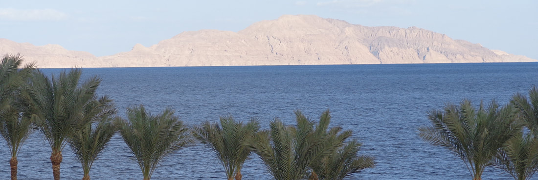
Sing: Wash, O God, Our Sons & Daughters, UMH 605 After our tour of Saint Catherine’s Monastery we re-boarded our bus and headed back the way we had come last night – but this time we get to see the scenery. We cannot go west from Saint Catherine because the Egyptian Army has closed that road for security reasons. So we are headed east and then south to the resort city of Sharm el Sheikh. My understanding of this “resort city” is that normal Egyptians do not get to live here or visit here unless they can come as paying vacationers. The workers of this “resort city” are bused in and out. The city itself was fairly clean but as we drove toward the city the desert was filled with plastic trash for miles. On Halloween of 2015 I was shocked to hear of a Russian charter flight that was blown up over the Sinai Peninsula after leaving Sharm el Sheikh International Airport. We drove past most of the city and approached it from the west. It is quite an amazing contrast to drive through the desert for several hours and then suddenly come upon the beautiful blue water of the Red Sea. The effect on me was to give me a strong desire to get into that water! I will get my chance this afternoon. Just north of the main civil harbor is a beautiful little bay called Sharm el-Moiya. This bay is about eight or nine miles up the Gulf of Aqaba coast from the southern tip of the Sinai Peninsula. Our tour guide had arranged a glass-bottom-boat ride for us. We walked out on a plastic pier that seemed to be built like a child’s toy with interlocking parts. After we boarded the boat and headed toward the entrance to the bay the sandy bottom began dropping below us. At about half a mile out the bottom rose again in coral reefs. We cruised around the entrance to the bay watching many different kinds of fish and seeing many different types of coral. The colors were amazing and everyone was mesmerized. After about an hour we headed in and our host took us topside to enjoy the sunny day – it seems we have left the cold weather in the mountains. After enjoying lunch we checked into our hotel, the Veraclub Queen Sharm. We have a free afternoon and I plan on going swimming in the Red Sea! This hotel has a pool deck and a nice beach from which we can see the islands of the Strait of Tiran, the mouth of the Gulf of Aqaba. There is a floating plastic pier which allows you to get beyond the shallow water to where the reef ends and the bottom drops precipitously. The bottom goes from being right there, two or three feet down, to not visible! I had a partner from our group and we jumped right in – it was cold, but not Jordan River cold. We adjusted to the temperature quickly and simply enjoyed floating there and letting the water massage away a morning of bus-riding. We noticed that the water seemed to be more salty than Texas Gulf Coast or Virginia Beach water. I hypothesized that this was due to the fact that there were no major (or minor) inflows of fresh water anywhere near us – unlike most of America’s coastline. This is another good way to end a day of touring! Read: Exodus 3 & 19 (www.biblestudytools.com/nrs/exodus/3.html)
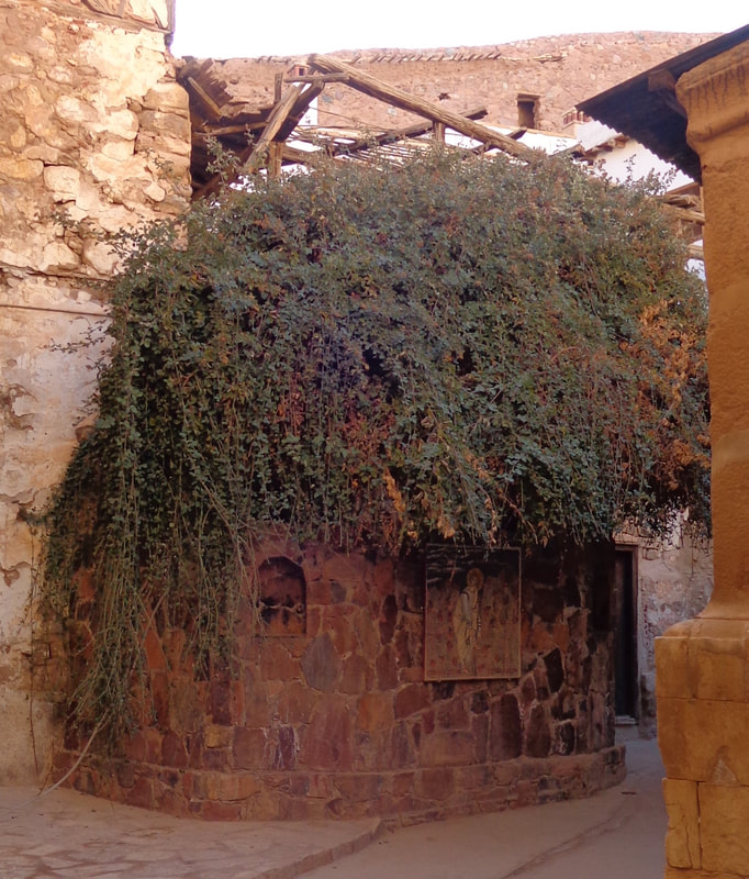
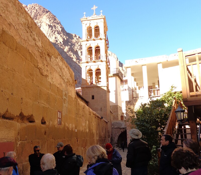
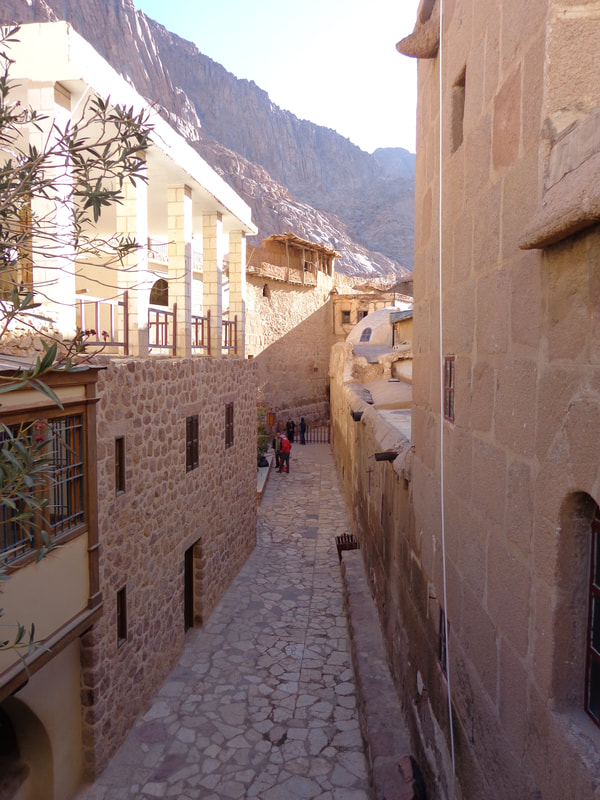
Sing: On Eagle’s Wings, UMH 143 Saint Catherine’s Monastery (I wrote about Saint Catherine back on Day 3 Site 3 of this devotional trip), also known as the Monastery of the Transfiguration, is situated at 5,249 feet in the high mountains of the Sinai Peninsula. It sits at the base of Mount Sinai (7,500 ft.) where Moses met with God, first at the Burning Bush and then later to receive the Ten Commandments and the Law. Christian hermits began to gather at Sinai from the middle of the 3rd century. The life that these early hermits followed was neither easy nor safe. The 4th and 5th centuries were particularly bad times, when Christians were not only persecuted, but suffered from barbarian assaults. Tradition holds that, in 330 AD, in response to a request by the ascetics of the Sinai, the Byzantine empress Helena ordered the building of a small church, dedicated to the Holy Virgin, at the site of the Burning Bush, as well as a fortified enclosure where the hermits could find refuge from the attacks of nomadic tribes. By 374 there were also churches at the summits of Mount Sinai and Mount Horeb. In the 5th century the growing population of hermits compelled their Bishop to request assistance from the Byzantium emperor Justinian. Justinian responded by founding a magnificent church enclosed within walls strong enough to withstand attacks and protect the monks against nomadic raiders. That compound is the Monastery of Saint Catherine. In the 7th century the monastery survived the Muslim conquest of the area through the direct influence of Mohammed himself, who saw the Christians as brothers in faith. In the 10th or 11th century a mosque, which still stands today, was built within the walls. Today it is not uncommon for a hundred or more pilgrims and tourists to visit the ancient sacred site in a single day. Greek Orthodox monks tend the monastery and its extraordinary collection of Byzantine art and illuminated manuscripts. The Well of Moses - Exodus 2: 15-22 Probably misnamed - but the story of Moses meeting the seven daughters of Jethro does not give this well a name. So it has become the Well of Moses, where he met his wife, Zipporah. The well probably had a name before Moses showed up but that name has been lost. It is still a functioning well today and helps supply the monastery the water they need. The Burning Bush You were not expecting to find the Burning Bush at the base of Mount Sinai – neither was I! It was transplanted here about eleven hundred years ago. It is a rare species of the rose family called Rubus Sanctus. This species is widespread in the Sinai and extremely long-lived, a fact which gives scientific credibility to the site. If you look closely you can see under the overhanging bush an icon of Moses removing his sandals. Read: Hosea 11:1-11 (www.biblestudytools.com/nrs/hosea/11.html)
Sing: Go Down, Moses, UMH 448 Our bus, bus driver, and guide could not go with us into Egypt so we grabbed our luggage and left them all behind with a fond, “Farewell and thank you.” The border crossing was relatively quick and painless and our buses and Egyptian guides were waiting for us on the other side. Taba Taba is Egypt’s border city. We got to see a bit more of Taba than we had planned. We missed our escort (the American embassy has asked the Egyptian government to provide escorts for every American tour group) and had to wait about two hours for the next escort. At first we were going to wait at a very small shopping center but then our guides made a few phone calls and we were taken to the Taba Hilton. The Taba Hilton is a very nice seaside resort. It is too bad that we could not get to our swim suits but our time will come. Pharaoh’s Island Pharaoh’s Island is the location of a Crusader fortress built by Baldwin I, the King of Jerusalem, around 1116 AD. The fortress was originally named Ile De Graye Castle. At various times while in Crusader hands, it was used to collect taxes on Arab merchants, and sometimes to attack Arab shipping, while at the same time protecting pilgrims traveling between Jerusalem and Mount Sinai. Pharaoh’s Island was captured by Salah ad-Din al Ayyubi (Saladin) in about 1170. He was the founder of the Ayyubid dynasty and is one of the greatest sovereigns in the history of Islam. Most of the business end of this fortress is on the eastern side, as the water is too restricted for attacks to have occurred on the mainland side. It is also notable that T. E. Lawrence (Lawrence of Arabia) made a somewhat daring and unauthorized visit to the island during his Wilderness of Zin survey in June 1914. This fortress would undoubtedly draw much larger crowds of tourists were it located in a more accessible location, but tourists who make an effort to visit the fort will usually have the island mostly to themselves. Climbing Mount Sinai As we were approaching our overnight stop our guide told us that we had the option of climbing Mount Sinai. This would involve getting up and leaving the hotel at about midnight and making the climb of over 2,200 feet during the night. We would get to watch the sunrise and then head back down the mountain to reconnect with our group by 9am. We would have Bedoin guides and later I found that you can hire a camel to ride up the mountain. We chose not to go. It was a long day of traveling but I get to wake up in the mountains in the morning! |
AuthorIn matters of faith, we at First United Methodist Church, Sealy put primary reliance on the Bible. In scripture, we understand that we are all God’s children; therefore, we will be a church that cares for the needs of our church and local community through prayer, deeds, inspiration, and love in the spirit of Christ. Archives
July 2020
Categories |
Location |
Our MissionCaring for the needs of our church and community through prayer, deeds, inspiration and love in the Spirit of Christ.
Sunday Worship: 10 am Adult & Children & Youth Sunday School 9 am First Kids Mother's Day Out (Tuesday & Thursday; 8am to 2pm; Ages 1-3) Rev Pat Bell, Pastor First United Methodist Church Sealy
200 Atchison Street Sealy, Texas 77474 979.885.2223 |
Contact Us |



 RSS Feed